
I want to preface this very long narrative by saying that I am not the best writer in the world and that the English language has always been a challenge for me, but I will try my best to give everyone a description of the Armand Bayou Estuary system. I was fortunate to finally locate an interactive map that I think will help a bit with my description of the bayou. I might also add that the interactive map on Flickr works nicely as well.
This map is provided by Anyplace America and you can access it at the link below.
https://www.anyplaceamerica.com/directory/tx/harris-county-48201/parks/armand-bayou-park-2028841/This map is provided by

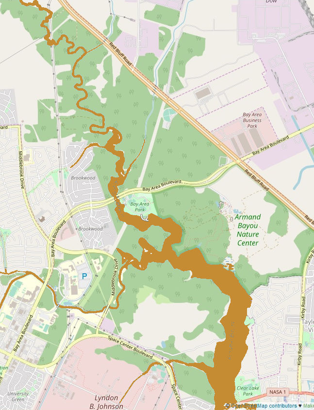
The map below is provided by OpenStreetMap. It will give you a good idea of the overall layout of the bayou system and how it snakes it way through the Houston/Pasadena/Clear Lake City area. The map covers an area that is approximately 5 miles by 3.5 miles. Doesn't seem like a huge distance, but the bayou doesn't run straight and it takes a while to paddle the entire length. You can spend an entire day in just one tiny area. If you are interested in a bit more detail, please check out the interactive map above.
Just a quick note. I highlighted the bayou in gold on the map so that it would show up better.
Many people have asked me to take photos of the bayou and I have tried to do that but determined that it would be difficult to show everyone what the bayou area is really like. Someone asked if you could get lost and the answer is yes, if you don’t keep your wits about you, but once you view a map of the bayou and stay focused, getting lost is not a problem. I will add that it’s not a complex place, but there is a technique for determining just how the bayou snakes its way through some of the areas. That can be difficult to determine when you are sitting in a canoe or a kayak and not peering down from on high.
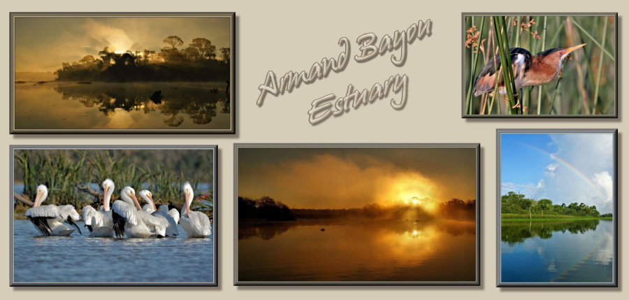
And so here we go. The put-in point for me is at Bay Area Park where Armand Bayou passes under Bay Area Blvd. There is a boat ramp, but I have always used the loading ramp for the pontoon boat. At this point you have a choice of either heading north or south. This is the Armand Bayou Estuary which connects with Horsepen Bayou a bit to south of the park. Where they join and flow toward the Gulf is referred to as Mud Lake. There is also a section in there referred to as Pasadena Lake before it heads to the south. Armand Bayou eventually meets Clear Creek and becomes Clear Lake before flowing into Galveston Bay. After that if flows into The Gulf of Mexico. This connection to the Gulf means that the estuary system is affected by the tidal flows and by any heavy winds that may sweep through the area from both the south and the north.
We’ll launch the canoe and head north under the bridge and set the map to Satellite view. Keep your eyes open because you never know where you will see something. You will notice a split just to the north of Bay Area Blvd. where Big Island Slough branches off to the right. In my 30+ years of paddling on the bayou I have only been up Big Island Slough twice and don’t find it very interesting. I always go to the left and up Armand Bayou. At most times the water is deep enough so that you don’t need to worry about paddling, but at certain times of the year you can get stuck in the mud very easily. You just must poke your way around and continue to head north.
As you make you way north you will see the bayou snake to the east and west, but you will always be heading north. The birds are a bit difficult to locate, but they are there. There are markers on the bayou, but I must admit I quit referring to them as I get them wrong all the time. You can paddle for quite some time to the north before you reach yet another branch in the bayou. Spring Gully will be to the right and take you up under Red Bluff Rd. I once again stay to the left and continue to paddle up Armand Bayou. It sort of doubles back on itself, but if you continue to paddle it will continue to take you north.
This was once a fairly open part of the bayou and all a person had to do was duck under a few branches and such and keep paddling. The bayou is very narrow at this point and very intimate. Hurricane Ike blew several trees down in this area and I will admit that it has been years since I have been this far up the bayou, but it does continue to run up under Genoa Red Bluff Rd. It also gets far too narrow to paddle and I have never made it up that far. When you get this far it may not be possible to turn a 16-foot canoe around. Years ago, there was a golf course near Genoa Red Bluff Road, but it was sold, and someone built apartments in that area. To get back to the park, all you need to do is a bit of back-tracking. If you are taking photos and trying to get a decent capture of something, you’ll never make it this far unless you stay out the entire day.
We now return to the put-in point and head south down Armand Bayou. If I arrive early enough at the park and the custodian has unlocked the gate, it is possible to catch some nice sunrise shots just to the south of Bay Area Park. The bayou turns to the west at this point before sweeping to the south and then to the west once again. It is at this point that Horsepen Bayou feeds into the system. You will see that in this area Horsepen Bayou has a shallow portion that sweeps back toward the north. The main channel heads to the west with some shallow flats on either side. Several years ago, there were three horseshoe shaped bends that you paddled through, but that has all changed and the first bend that looped to the north is no longer navigable even when the tides are high.
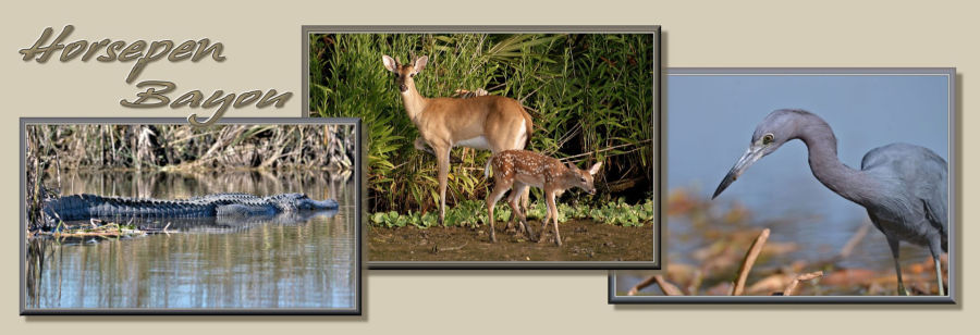
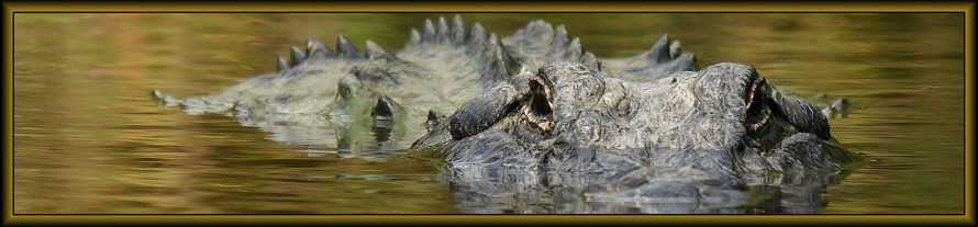
I will just say that this is the most interesting part of the bayou where you will find the most wildlife and especially at low tide. If you head west you will see that there are several ways to go. There is a horseshoe bend to the south and this is the part of the bayou that we refer to as Alligator Alley. This is where the largest concentration of alligators appear and you are more likely to see them here than anywhere else within the bayou system. You will also notice that after the bend to the south that there is a double loop to the north. I don’t find a lot of animals on the short loop and always paddle up and around the longer loop to the north. At the northern-most part of the loop you will see a shallow area to the west, but most of the time this area is too shallow to paddle. I usually stick to the flow of the bayou and head to the south. When you are in this area you need to keep your eye on the western bank of the bayou because this is the domain of Big Al, the largest gator in the neighborhood. Even though he’s the largest he is not the easiest to spot at times and especially in the summer months. During the heat of summer, you may have a difficult time just spotting an alligator. You just never know. The bayou turns to the south and continues to flow from Clear Lake City. It will turn back under Middlebrook Dr and eventually pass by University of Houston-Clear Lake and then pass Clear Lake High School. You might find some wildlife back in the area of the homes, but I have never gone past the High School.
I didn’t direct you toward the Gulf of Mexico after Armand Bayou and Horsepen Bayou join together because it’s a long paddle and far too wide. It’s also an area that I have never explored. I have chased some Pelicans in that area, but usually stick to the more intimate areas of the bayou system. Gas powered craft are not allowed on the bayou system and so it is always a nice quite easy paddle and you will usually find something worth pursuing.
Hope this has not been too confusing and hope it was not too long. If anyone has any questions, please don’t hesitate to contact me. I am also not the best at explain things and I hope it is not too confusing. This is the Armand Bayou and Horsepen Bayou system. Hope you enjoy.